
Arches & Canyonlands
utah travel backcountry whitewater american-southwest

For his 60th birthday, my father, who has always loved hiking, mountaineering, and the outdoors, decided he wanted to go on an adventure with his family. He settled on rafting the Colorado River through the Grand Canyon as his expedition of choice. Unfortunately, Grand Canyon trips tend to fill up as early as two years in advance, and we weren’t able to book one. Instead, we decided to raft the Colorado through Cataract Canyon. Cataract Canyon is in Canyonlands National Park, above the Grand Canyon, and has even bigger whitewater.
I flew with my parents from Oakland to Salt Lake City, Utah. We rented a car and drove four hours to Moab. Until recently, a regional air carrier served Moab, but that carrier switched to an all-jet fleet, and the runways at the Canyonlands Airport are too narrow for jets. There are rumors that another carrier will pick up the route, but at the moment it isn’t possibly to fly commercially anywhere closer to Moab than Salt Lake City. Hence the long drive.
We arrived in Moab in the early evening and checked into our hotel, the Gonzo Inn. Moab is a very small town nestled among the beautiful red rock canyons of southeastern Utah. It seems to consist only of hotels, adventure outfits, craft and gift shops, and a few restaurants and cafes. We walked around Moab a little bit and then had dinner at the Broken Oar, a fun restaurant serving typical American fare.
The next day we visited Arches National Park, the entrance to which is just north of Moab. Arches is aptly named, and for the most part it is structured around the eponymous natural stone arches and bridges. A typical trip to Arches involves several stops and short hikes to the nearest arches or other rock formations.
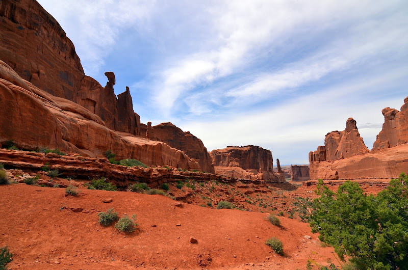
We started our tour with a visit to Park Avenue, a canyon surrounded by sheer vertical walls. The walls are so high and steep that walking down the canyon is something like walking down a street in Manhattan with skyscrapers on either side. A number of stunning rock formations are visible from Park Avenue, including Queen Nefertiti, Courthouse Rock, and the Tower of Babel.
Our next stop was Balanced Rock, a massive boulder resting on a narrow column that suspends it about 75 feet off the ground. The layer of stone under the boulder is softer than the boulder itself, so the support has eroded faster than the boulder. There’s a short hiking loop around Balanced Rock that lets visitors view the formation from all angles, and on the far side there’s a great view of the La Sal Mountains in the distance.

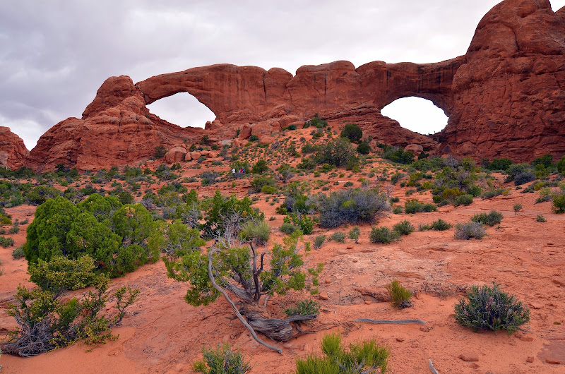
We continued to the Windows, a set of two arches in the same rock wall, referred to as North and South Windows. The same parking lot also serves Double Arch, a set of two arches that share an endpoint, creating a V-shaped formation. The walk around the Windows provides beautiful views of the surrounding desert and mountains, and the short hike to see Double Arch up close is also absolutely worth it.
After the Windows and Double Arch, it was early evening, and we were tired. But we decided to visit Delicate Arch anyway. Delicate Arch is probably the best-known arch in the park. It’s sixty-five feet tall and, unlike most of the arches in the park, it’s a free-standing structure. It’s depicted on Utah state license plates and postage stamps. The hike out to Delicate Arch is about a mile and a half, with about 500 feet of elevation gain. The park service estimates that the hike should take 2-3 hours round trip, but we moved fast and reached the arch from the parking lot in under half an hour.
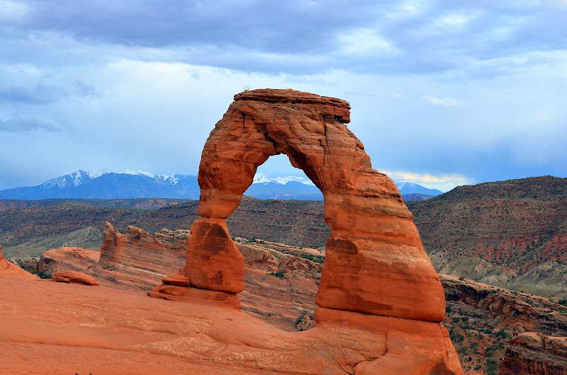
Delicate Arch is an amazing sight. It sits on the edge of a cliff, and the desert and La Sal Mountains are visible beyond it. Unfortunately, the area around the arch was crowded; there were probably seventy other people there even though it was already close to sunset. I managed to snap a few pictures of the arch with no one visible in front of it, but there were very few opportunities to do so. The people around the arch were constantly posing beneath it and walking up close to take their own photos. After taking the incredible views of Delicate Arch, we returned to our car and drove back to Moab. We picked up a pizza from Paradox Pizza and then returned to our hotel.
The next day we visited Dead Horse Point State Park. Multiple people had recommended the park to us, so we were excited to see it. Dead Horse Point is a large plateau that drops off steeply to the canyon below on three sides. The fourth side is a ridge that connects the point to the outside world. At it approaches Dead Horse Point, the ridge narrows to only about thirty feet wide. The point gets its name from a legend that cowboys used it as a corral for wild mustangs. The cowboys would block off the point where the ridge narrowed to create a corral, pick the mustangs they wanted, and leave the rest to die of thirst.
There are two main hiking trails in the park: the west rim and east rim trails. They form a loop around the point. We began hiking the west rim trail and started with a detour to Bighorn Overlook, an outcrop that overlooks a beautiful canyon. The overlook is about a mile and a half from the visitor center.
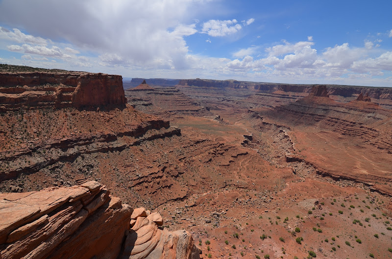
We returned to the visitor center from Bighorn Overlook and had lunch there. Our plan was to hike the loop out to Dead Horse Point, but we noticed that the road goes all the way out to the point. So we drove instead. The view from the point is spectacular, but the hike didn’t seem to be worth it. While the hike lets visitors view the canyon from other perspectives, the views really aren’t all that different. Dead Horse Point State Park is definitely worth a visit, but you don’t need more than half a day there, and don’t expect to do much hiking.

By the early afternoon, we’d seen everything Dead Horse Point has to offer. We drove back to the Gonzo Inn and spent the rest of the afternoon reading and relaxing in the pool and hot tub. That night we went to the Desert Bistro to celebrate my dad’s birthday. The Desert Bistro has truly outstanding food, and we had a great time there.
The following morning we woke up early. We drove out to the end of Arches Scenic Drive, the main road through the park, to Devil’s Garden Trailhead. There are several ways to do the hike out of Devil’s Garden. The primary trail, which is very well maintained and easy follow, stretches 1.1 miles to Landscape Arch, with stops at Tunnel Arch and Pine Tree Arch along the way. We went straight to Landscape Arch, which at 290 feet is the longest natural arch in the world. The arch is absolutely stunning, and while visitors can no longer hike under the arch, the viewing area still provides a great view of the arch from multiple perspectives.

Once the trail reaches Landscape Arch, it splits. The primitive trail loops north and then west, while the semi-primitive trail runs further west. Both trails converge at Double-O Arch; the primitive trail is a little over 3 miles, and the semi-primitive trail is about 2 miles. The best way to do this hike is to reach the parking lot early in the morning (before 8 am), so the park is not yet hot or crowded, and go straight to Landscape Arch before the crowds arrive. Then backtrack a little ways to the fork with the primitive trail, and follow it out to Double-O Arch. At Double-O Arch, take the semi-primitive trail back to Landscape Arch, following the detours for Navajo and Partition Arches along the way. If you want, you can stop by Tunnel and Pine Tree Arches on the way back to the parking lot. In total, the whole loop is a little over 7 miles. If you want a longer hike, you can continue past Double-O Arch to Dark Angel, a tall rock spire.
The primitive trail only accesses one arch, Private Arch, that the other trails don’t visit. Private Arch is not very impressive and not worth taking the short additional hike to see it up close. But the primitive trail is a great hike that offers beautiful views of the desert around Arches, the La Sal Mountains, and some very impressive rock formations.

After three miles, the primitive trail reaches Double-O Arch. Double-O Arch is an amazing formation composed of two round arches stacked on top of one another. The arch is plenty impressive as you approach it from the trail, but it is truly breathtaking if you walk through the lower arch, up the slope behind it, and look at it from the other side. An expansive vista is visible through the upper arch, and beautiful rock formations are visible in the distance.

We continued the loop by turning on to the semi-primitive trail. From Double-O Arch, the trail follows a ridge that boasts great views of the distant desert. The trail also runs by Navajo and Partition Arches, both of which are definitely worth visiting. Partition Arch is actually two arches side-by-side, and the there’s a great view through the larger arch. Navajo Arch is a beautiful tunnel that opens into a round open air chamber.

We returned to Landscape Arch, which was now packed with people. We continued down the main trail back towards the parking lot, stopping at Tunnel Arch and Pine Tree Arch along the way. Neither has the majesty of Landscape Arch or Double-O Arch, but both are worth visiting. When we reached the parking lot, it was about 11:30; the hike took us about three and a half hours. If you want an even longer hike, you can start at Sandstone Arch and follow the trail to Broken Arch, which connects to the Devil’s Garden campground. You can follow the road to Devil’s Garden trailhead and then do the 7.2 mile loop that we did.
After finishing the Devil’s Garden trail, we drove to Skyline Arch. Skyline Arch is embedded at the top of a tall rock wall, and a hike of about a quarter of a mile takes you to the base of the arch. We also visited Sandstone Arch and the Fiery Furnace, a maze of sandstone walls. You need a permit to hike within the furnace itself, but an overlook provides a good view of the formation.

As we left Arches, we noticed several Moab Police cruisers and National Park Police vehicles controlling traffic on the highway just outside the park. It was lucky we got to the park so early: the Memorial Day visitors overwhelmed the park, forcing the park service to close Arches for the first time ever. The park’s structure also renders it vulnerable to overcrowding. It is a relatively small park, and it seems designed for driving tours and short hikes. There are limited opportunities to take longer hikes or backpack. Unfortunately, despite the orientation towards driving, parking is limited and the lots fill up fast.
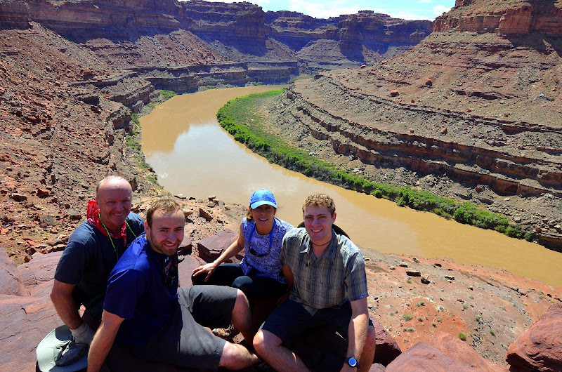
When we returned to Moab, we met my brother, Jake, and our close family friends, the Henry-Lacey family, who had flown into Salt Lake City earlier that day. In the evening, we met in the breakfast room of the Gonzo Inn for a pre-trip meeting for the rafting trip, which would be run by OARS (Outdoor Adventure River Specialists, one of the oldest and best guiding companies on the Colorado River). We me the lead guide, Lars, picked up the dry bags that would protect our things for the next six days, and received some instructions. After the meeting, all eight of us went to dinner at the Broken Oar. The food was still good, but while the service was outstanding on our first visit, it was pretty bad the second time. Nonetheless, we had fun. We returned to our hotels, packed our things for the rafting trip, and went to bed.
Early the next morning we woke up and drove to the OARS warehouse. We met the rest of our group there, a total of 20 clients, and piled into two massive Econoline vans. We drove north out of Moab and turned off the highway toward the town of Potash. We made a brief stop to look at some Indian petroglyphs—symbols and drawings carved into the desert varnish that coated the rock walls above the road. Shortly after getting back in the vans, we reached our put-in just beyond Potash.
Our flotilla consisted of five boats: three rafts and two dories. Dories are small, rigid boats that resemble rowboats. Unlike rafts, dories cannot flex with the flow of the rapids and instead either cut through the waves crash and rock over them. Each boat held four clients and one guide. We met the other four guides on the trip: in addition Lars, our guides were Christian (also known by his last name, Dean), Ben, Brian, and Emily. OARS also provided three inflatable kayaks (IKs) and a stand-up paddle board for us to row down the river.

Our first day on the river was entirely on flat water; there were no rapids at all. I rode in a dory with Jake and Lars. As we rowed, we got great views of the canyon above us. We also saw some beautiful birds native to the area: a great blue heron, a yellow-breasted chat, and two peregrine falcons, one of which narrowly missed catching a sparrow after a long dive. We camped that first night on a beach on the left bank of the river. The guides cooked us a delicious dinner of salmon and grilled asparagus. Lars tried to give us an astronomy talk, but clouds started rolling in, blocking most of the stars from view and turning Lars’s chat into a hypothetical astronomy lesson. As soon as we went to bed, the skies opened, and it started raining hard. I fell asleep to the sound of raindrops pounding on the tent.
The next day dawned sunny. Once again, the river was completely flat. We stopped for a short hike to see some Indian pictographs. Pictographs are painted on the rock, in contrast to the petroglyphs we’d seen earlier, which are carved. After the hike, I tried the stand-up paddle board. I’d never been on one before. It was fun, and surprisingly fast and forgiving. At least two or three times, I was sure I’d overbalanced and would flip the board. But the board caught me and pushed me back up. While I had certainly grown to appreciate the meandering pace of floating the river, riding the paddle board provided a nice change of pace as well as some much-needed physical exertion. We reached our camp in the late afternoon, this time on an island in the middle of the river. I took a swim in the river, which felt great, both because it was so hot and because it felt wonderfully cleansing. Lars cooked us an excellent dinner of chicken tikka masala, and we played an intense game of freestyle bocce ball before bed.

Our third day on the river was mostly more rowing down flat water. In the morning we paused at the beginning of a long horseshoe bend in the river. While some of the guides paddled the boats around the horseshoe (about four miles of river), we hiked over the ridge at the narrowest point of the horseshoe. The top of the ridge provided great views of the canyon around us.
After lunch, I took a turn paddling one of the IKs. I’d paddled a whitewater kayak years before, on the Snake River in Wyoming, but IKs are very different. They’re like miniature rafts: very stable, but harder to maneuver than real kayaks. I was in a two-person kayak with my dad. Paddling the IKs down the flat water was hardly a challenge; the current tended to spin the boats gently, but we could choose whether to paddle or simply sit back and the let the river carry us downstream.
Just before we reached our camp for the night, we hit our first rapid. It was small (probably a big class 2) but fun to ride. We made sure the IK was squared up to the waves and made it through easily. The only difficult part was catching the eddy at the end of the rapid. The whitewater continued past our campsite, and we had to make a sharp right turn and paddle hard to exit the rapid and enter the gentle water of the eddy.
Our campsite for the night was on a long, beautiful beach. But as soon as we tied up our boats it started raining. The storm didn’t last long, but it made the sandy beach muddy enough to make setting up camp a little unpleasant. We spent the afternoon relaxing and drinking a few beers. Dinner was delectable again: spaghetti and meatballs with garlic bread and salad. I went to bed a little after ten, but I woke up at around three in the morning. The sky was completely clear, and the moon had set, so the sky was dark, and the stars were incredible. I spent about an hour taking pictures of the night sky.

Lars woke us up early the next morning. We ate breakfast and started a long hike. Our destination was the Doll House, a labyrinth of sandstone spires and towers on the top of the canyon wall, about 1000 feet above the river. The first part of the hike was in the shade, but as soon as we rounded a bend in the river and began our ascent, the sun hit us. Despite our early start, it was hot, and the trail was steep. But we were rewarded with gorgeous views of the canyons around us and of the Doll House itself.

After taking in the view, we hiked to an Indian granary. The Indians who lived in the area would grow crops, including corn and squash, in the desert valleys. When they left the area for the winter, they would build granaries out of mud bricks and wood to store food and seeds for the next spring. The hike then took us into the Doll House, through a narrow passage between two sheer rock walls, and into a cave known as “The Refrigerator.” The cave’s temperature is naturally regulated, so it remains cool throughout the summer. Then we descended the canyon wall and returned to camp for lunch.

After lunch, we launched our boats. We would only spend about an hour and a half on the river, but we’d be on whitewater almost the entire time. These rapids would be bigger than the small one we rode the day before; this time the rapids were in the class 2/3 range. Once again, I was in an inflatable kayak with my dad. After we kayaked through two rapids uneventfully, we entered a large class 3 rapid. Suddenly an enormous wave loomed in front of our boat. We hit the wave head on, but it was taller than our boat was long (and the boat was about twelve feet). The front of the boat crested the wave, and my father, who was in the front seat, disappeared over the top. Then the boat buckled as the wave began to crash. The back end of the boat, with me in it, curled under the wave, and suddenly gravity was pulling me out of the boat instead of holding me in my seat. For an impossibly long moment, I knew that I was about to fall out of the kayak. I had time to say, “whoa,” and then I was under water.
I came up right next to the kayak and managed to hold onto my oar. My dad gave a one-handed tug on one of the should straps of my life jacket, and with his help I managed to jump back into the boat. We paddled the rest of the rapid and eddied out beneath it. It was exhausting, but we rowed the rest of the day’s rapids and reached our campsite on a beach.
All of us in the IKs were soaked; in fact, I don’t think falling into the river got me much wetter than I would otherwise have been. Fortunately the sun was hot, and we dried very quickly. As the guides prepared dinner, we played bocce ball on the beach. Brian also introduced us to washers, a game a bit like horseshoes, but played with large washers and PVC cups planted in the sand. We had another great dinner, burritos this time. The night was warm and clear, so I spent a wonderful night sleeping under the stars.
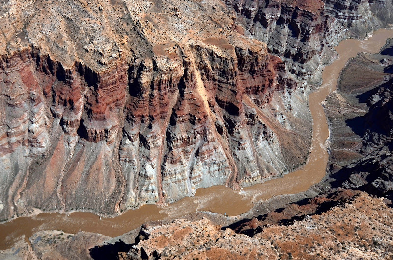
Our fifth day on the river took us through almost constant whitewater, and once again it was bigger than it had been the day before. The rapids were classes 3 and 4, and the biggest were pushing class 5. The guides told us that the water was now too big for us to row the IKs. My parents, my brother, and I joined Christian in his dory. Riding the dory through the whitewater was great fun. It cut through the small waves and crashed over the large ones, rocking back and forth crazily each time. One of our guides explained that the difference between a raft and a dory was like the difference between a school bus and a Porsche. I agreed.
We ran Mile-Long rapids, an aptly named mile-long stretch of pure whitewater. As the morning turned towards afternoon, we reached the Big Drops, a series of three rapids through which the river drops thirty vertical feet, and the biggest rapids in Cataract Canyon. The first Big Drop was a fun ride, and we pulled out of the current into an eddy on the left side of the river once we were through. We disembarked and walked up a ridge that overlooks the next two Big Drops. The guides huddled to discuss their strategy. They wanted to avoid the most dangerous features of the rapids, including a massive hole called “Satan’s Gut” and a waterfall created by a large rock known as “Little Niagara.”
After the intense anticipation, actually running the Big Drops turned out to be a bit of a let down. Christian did such a good job steering the boat that we never felt even close to being in danger of flipping. But we could tell that he was exerting himself intensely to keep us on course; he was grunting, puffing, and straining at the oars as we cruised through the whitewater. And though our boats made it through the whitewater without incident, the group that followed us showed just how challenging the Big Drops can be. The group after us was a private group (no professional guides) in five inflatable rafts. Two of the rafts flipped on Big Drop 2, and our guides had to help push the inverted boats into an eddy.
We camped that night on yet another beautiful beach. We had a bonfire to celebrate our last night on the river, and our guides cooked us a pork tenderloin stew with mashed potatoes and vegetables. The next morning we woke up early to make sure we’d get to our takeout point on time. When we left our campsite and immediately ran two more rapids. Those rapids marked the last whitewater we’d see on our trip.
The guides began rowing us down the flat water below the rapids. About an hour after we’d passed the last rapids, another OARS trip caught up with us. They’d done the same trip that we had, but they had two motor rigs on their trip that pushed them quickly through the flat water above Cataract Canyon. As a result, they could do the same trip in four days instead of six. They brought us an outboard motor, and we lashed our five boats together to form a single craft. The motor was attached to the raft at the back, and we started moving faster as the motor pushed along with the diminishing current.
We had a floating lunch aboard our motorized flotilla. Though the water was flat, the ride out still didn’t occur entirely without incident. While we were eating, the motor, which apparently hadn’t been properly attached to the back of the last raft, started to fall into the river. Christian, who was manning the motor, leaped after it, and almost fell into the water. He was saved when one of the clients on the trip dived for his ankles and held on to keep him in the boat. Another guide managed to reach them and pull them back into the boat. After about 15 minutes, Christian had the motor reattached and powering us downstream once more.
As we motored down the river, we passed the private trip whose boats had flipped on Big Drop 2 the day before. One of our guides checked in with them. “We’re sorry you guys had to see that,” one of them said. “It was a total shitshow.” At the time we’d noticed that they hadn’t stopped to scout Big Drops 2 and 3—“readin’ and runnin’,” as Christian calls it—but we learned that, not only had they failed to scout the rapids, they’d done so because they’d lost track of their position on the river and didn’t realize they were above the Big Drops.
Around one in the afternoon, we reached the upper end of Lake Powell. A massive reservoir created by Glen Canyon Dam, Lake Powell has submerged much of what used to be the Colorado River and many of the rapids that existed below Cataract Canyon. We reached our takeout point, a long dirt boat ramp that extended into the water. We tied up the boats and unpacked them for the last time.
A short drive took us to a small, wandering airstrip in the middle of nowhere. After a few minutes, five planes, ranging in size from three seats to nine, landed and slowly turned around at the end of the runway. I joined my family and the Henry-Laceys in the nine-seater, which was piloted by Mark, who happened to be Christian’s uncle. I sat in the copilot’s seat and put on a pair of headphones so Mark could tell us about the scenery beneath us. We were the first to take off. The plane rumbled down the crooked runway, and we lifted off. The runway was situated so that it faced a canyon wall, and almost as soon as we took to the sky, an alarm went off.
“Terrain! Terrain! Pull up! Pull up!” said the plane’s automated voice in my headphones.
Mark reached down to shut off the alarm and banked to the left. “Sorry about the terrain alarm, folks,” Mark said. “It’s just that the runway is positioned so that we have to take off toward the rocks. I promise I won’t hit anything I can see.”
The flight back was beautiful. We flew over most of the route we’d just rafted. We could see the Big Drops, the Doll House, and the ridge we hiked over to cut off the big horseshoe. After about forty minutes, we touched down at Canyonlands field.
Another set of Econoline vans picked us up at the airport and drove us back to the OARS warehouse. We dropped off our dry bags and said our final goodbyes. We drove into Moab and had a celebratory dinner at Jeffrey’s Steakhouse with the Henry-Laceys. The next morning we woke up early, drove back to Salt Lake City, and flew home.
Reviews From this Trip
Lodging
- Gonzo Inn: 7/10 (Good). Friendly staff, nice facilities. We stayed in a room with a bedroom and pullout sofa in the common area, which also had a fridge, microwave, table, and small porch overlooking the pool. The included breakfast is not so great; it was limited to juice, yogurt, biscuits, bagels, and cereal.
- Best Western Plus Canyonlands: 8/10 (Very Good). Very nice hotel with beautiful pool/spa. Great wrap-around porch with view of Moab. The Signature Suite was great: it had two bedrooms, a common area with tables, a desk, microwave, and refrigerator. Helpful, attentive staff.
Dining
- The Broken Oar: 8/10 (Very Good). Fun atmosphere, good but not great food. I had the chicken Caesar salad, sweet potato fries, and cheesecake. Service was hit or miss (one great server, one pretty bad one).
- Desert Bistro: 10/10 (Outstanding). Expensive, but absolutely delicious food with incredible presentation (had salad + Hawaiian grouper). Full bar, great margaritas.
- Paradox Pizza: 6/10 (Above Average). Pretty standard, above-average quality pizza. Salads are also OK.
- Jeffrey’s Steakhouse: (7/10) (Good). Great steaks in a charming sandstone building. A bit overpriced. Most of our party really enjoyed their meals, but I had the chicken fried steak, and it wasn’t very good at all. The steak was a bit rubbery, and it’s served in a brown sauce (rather than gravy, which I prefer), that also isn’t great.
Excursions
- Arches National Park: 7/10 (Good). beautiful rock formations. Gets crowded, and parking is terribly inadequate. Definitely possible to see everything in 1-2 days.
- Dead Horse Point State Park: 6/10 (Above Average). incredible view of canyons and Colorado River, but no real hiking. Possibly great opportunities for mountain bikers and/or off-roaders. It’s worth it to visit for the view alone, but unless you’re planning on doing a biking or off-roading trip, do not plan to spend more than half a day here.
- OARS 6-day Cataract Canyon trip: 9/10 (Excellent). Overall an excellent trip. The guides were fantastic, the food was great, and the whitewater was incredibly fun. Floating on flat water for 3+ days could get monotonous at times (to avoid that, you can opt for the alternative four-day trip with motor rigs). Great to be able to ride dories (and IKs/SUP). Many of the women on the trip felt that some of the trip policies (for example that all liquid waste go in the river) were hard for them, and that the male guides weren’t sensitive enough to the difficulties these policies created.