
Svalbard

“The bleakest barest most inhospitable godforsaken dead end of nowhere.”
Arrival
So the character Lee Scoresby describes Svalbard, an archipelago in the far north, in Philip Pullman’s excellent novel The Golden Compass. Nonetheless, visiting Svalbard has been a dream of mine since childhood, a dream that was partly inspired by that book. Apart from the literary basis, Svalbard is beautiful, has a fascinating history, and is one of the most accessible parts of the high arctic.
I left for Svalbard from San Francisco early on a Monday morning. I flew through Newark, Oslo, and Tromsø, finally reaching Longyearbyen, on the island of Spitsbergen, at around 2:30 on Tuesday afternoon. Longyearbyen is the administrative center of Svalbard, and though Svalbard is officially part of Norway, visitors are required to go through passport control as they leave Tromsø. When my flight landed, I took the Flybuss from the airport to my lodgings, at the Spitsbergen Guesthouse.

The Guesthouse is actually a converted miners’ barracks, and its history is obvious. The buildings are spartan, the rooms are small, and the bathrooms are shared. It is also in a terrible location—out of town up towards the mines, a good 25 minute walk away from the center of town where the restaurants, shops, and bars are. It’s also at a higher elevation, so the return is actually a bit of a hike. But it’s clean and warm (which are the most important), and all the hotels in town cost more than twice as much.
After checking in, I walked down into town. Svalbard’s terrain is barren. The ground cover on the archipelago is 13% vegetation, 27% rock, and 60% ice. The vegetation is almost all low grasses—there are very few shrubs and no trees at all. The climate is dreary during the summer; it’s always at least partly cloudy. Temperatures are usually in the 40s, but it feels colder because it is almost always rainy and/or windy. It never rained hard while I was there, but it drizzled enough make it feel cooler.

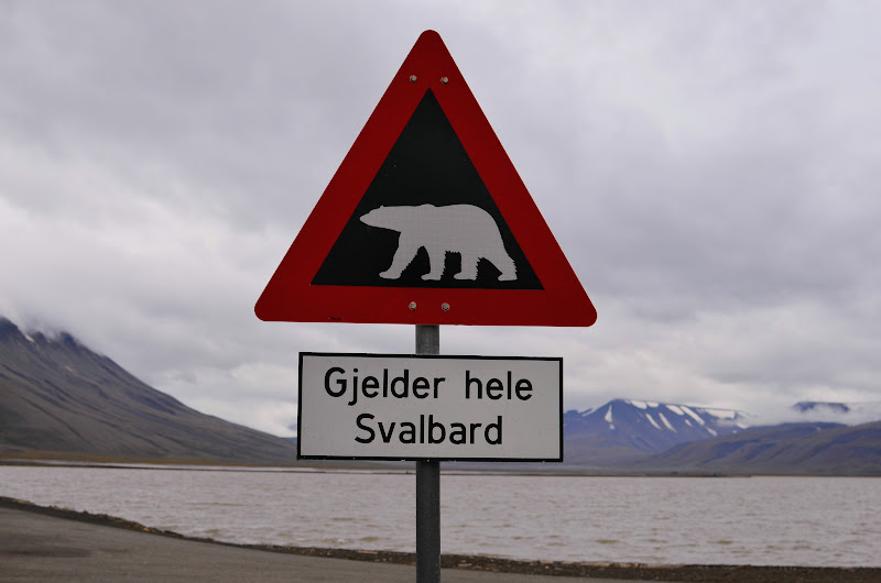
Longyearbyen is a remarkably well developed city given its remoteness, but all of the buildings have a very functional look about them. However, many are brightly colored, so the town hardly appears monotonous. Svalbard is also home to a large number of polar bears. The bears are so dangerous and aggressive that anyone leaving the boundaries of the main settlements is required by law to carry a rifle. At each end of Longyearbyen is a sign with a polar bear on it reading “Gjelder Hele Svalbard,” which means “Applies to All of Svalbard.”
I spent the afternoon wandering through the shops, buying a few souvenirs and gifts. The first thing I noticed is that apparently I look somewhat Scandinavian. Everyone I talked to began speaking to me in Norwegian, and most seemed slightly surprised when I responded in English. That’s a first for me: in every other country I’ve visited (including Germany and Switzerland), people could tell immediately that I was a foreigner, and usually that I am an American.
I snapped a few photos of Longyearbyen, and then walked a short distance outside of the town center to Svalbard Kirke, the northernmost church in the world. I couldn’t go inside, but it was still neat to see.

I ate dinner at Kroa, a restaurant in town. It was great. The food was delicious, and the restaurant has a neat ambience. It’s almost all wood inside, and the tables and chairs are made from driftwood. There are reindeer skins and antlers on the walls. Happily full but starting to feel jet-lagged, I walked back to the Guesthouse and went to bed.
Horseback Riding
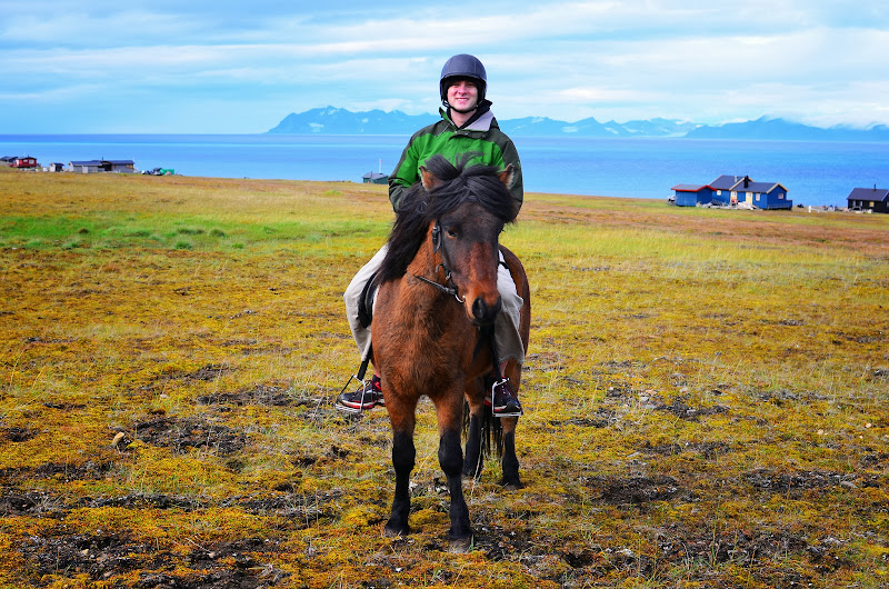
On Wednesday morning I woke up and went to breakfast at the hotel’s complimentary continental breakfast, which definitely leaves something to be desired. At 9 o’clock, my horseback riding guide picked me up. Her name was Ada, and she was Swedish. During the year, she studied animal science and economics at Uppsala University, and she spent her summers wrangling horses and guiding mountaineering, glacier hiking, and riding trips in Svalbard and Iceland.
She drove me to the stables, which are out near the airport. All the horses are Icelandic horses, which are short but strong, very calm and easy to handle, and deal well with cold weather. My horse was a dark brown one named Tengil, for an evil king from Scandinavian folklore who always rides an Icelandic horse. I groomed him, and then we mounted our horses and rode off. Complying with the law, Ada had a rifle strapped to her saddle.

The actual ride was a little disappointing. We just rode in a big loop around the airport. We did get some incredible views across the ocean at the islands on the far side of the fjords, and we could see enormous glaciers snaking down them into the sea. Tengil was a pleasure to ride, and he has a very smooth gallop. The horses do not wear shoes because there is no blacksmith in Svalbard, so we had to check their hooves for rocks and pebbles when we returned. Nonetheless, when we galloped, we flew across the tundra along the coast. Then we returned to the stables, unsaddled the horses, and Ada drove me back to town.
Svalbard Museum
I walked around town for a little while and wandered into the Svalbard museum, which has an interesting exhibit about the human and natural history of the area. Svalbard was discovered in 1596 by the Dutch navigator William Barentsz during a search for the Northeast Passage. Barentsz died before returning to Holland (while wintering on Novaya Zemlya), but his expedition brought his maps back. Svalbard quickly became a base for whaling in the arctic; it was swarming with Greenland Right whales, which have unusually high amounts of blubber and are slow and easy to kill. One captain sailing into Svalbard in 1612 wrote that there were so many whales around the islands that he practically had to break his way through.
Within 150 years, however, the Right whale had been hunted nearly to extinction. Those whales that had survived were far out in the ocean, and the whalers left Svalbard for good. The islands remained popular for hunters seeking walrus, seal, and fox, but it wasn’t until the late nineteenth century that Svalbard became important economically.
Russian, British, and American mining companies began operations to produce coal and gold on Svalbard towards the end of the 1800s. But Svalbard had never been claimed by any country, so there was no law to govern property claims. At one point, the amount of land specified on mining claims actually exceeded the total amount of land in the archipelago. Amidst all this confusion, an American mining company established a large year-round coal mining operation on Spitsbergen, the largest island in Svalbard, in 1906. The company’s primary stockholder was John Munro Longyear, who gave his name to the company town—Longyear City. When a Norwegian mining company purchased the operation in 1915, the city was renamed to Longyearbyen.
By 1920, the ad hoc approach to law that had governed Svalbard was no longer functional, mostly because the mining companies needed to settle their claims. The Svalbard Treaty was signed, which gave Norway sovereignty over the islands but required Norway to grant access to property ownership and economic opportunities on an equal basis, regardless of nationality. The law also prohibited Norway from using taxes collected from Svalbard for anything other than the administration of Svalbard itself, so taxes are much lower than anywhere else in Norway.
During World War II, Germany captured Svalbard to commandeer its coal mines to support the steel industry. The Germans built an airstrip on Spitsbergen, and the remains of a German plane destroyed by an Allied air raid still lie on the site. After the war, Svalbard began to change. Today it supports a bustling adventure tourism industry and is a mecca for scientific researchers—meteorologists, biologists, and climate scientists from many countries all do research here.
After the museum, I ate lunch at Svalbar, a relatively hip and upscale bar and restaurant in the middle of town. The food was quite good, but I didn’t like the atmosphere nearly as much as Kroa. Then I hiked back to the hotel.
Dog Sledding
At 3:30, I set off to go dog sledding. There’s not enough snow to go sledding during the summer, so they use special wagons instead. My guide, Tomos, picked me up and drove me to the kennels to the east of town. The company I went with, Svalbard Husky, has 55 dogs, all of whom are very friendly and were extremely excited to have a visitor, crying out for me to come meet them so they could jump up into my arms.

I walked around the kennels, meeting all the dogs. As I did so, a beautiful reindeer strolled up to the edge of the kennel. He was large because he was putting on a lot of weight to survive the winter and had a huge set of antlers. Svalbard actually has its own subspecies of reindeer, the Svalbard Reindeer.

As I snapped a few pictures, Tomos designed a team to pull our sled, with Dino, a slightly undersized husky with stunningly blue eyes, as our team leader. He picked 8 dogs (they usually only use 6 for the smaller sleds), most of whom were young—6 of the dogs were only a year old. We harnessed the dogs together and then got ready to leave. Tomos sat in the front of the wagon while I stood in back with control of the steering and brakes.

Because we had 8 relatively young dogs, and only one sled, we flew out of the gate. We moved so quickly at first that I was a little uncomfortable and had trouble steering. I got the hang of it pretty quickly, though, and dogs slowed down a bit. We drove along the site of the German airstrip from World War II, and then up Adventdalen, a gorgeous glacier-carved valley with an old mine clinging to its eastern rim. At the end of the valley, we paused for tea, cookies, and biscuits. But the dogs were so strong and eager that they could pull the sled, even with the brakes locked. As we were eating, they took off with the sled, and Tomos had to sprint after them, throwing his cup of coffee behind him, leap onto the wagon, and yell at the dogs to get them to stop.
After that little adventure, I drove us back to the kennels. We unharnessed the dogs and then thanked them by feeding them a delicious dinner of cow guts mixed with dry dog food and water. I said goodbye to each dog, and Tomos drove me back to my hotel.
I changed and walked into town for dinner. I ate at Classic Pizza, which wasn’t anything special but was slightly more reasonably priced than the restaurants (which were both expensive). Then I trekked back to my hotel and went to bed.
Hiortfjellet
I awoke early on Thursday, my second full day in Longyearbyen, to find the morning overcast and drizzly and gloomy. The only saving grace was that there wasn’t much fog; though clouds blanketed the entire sky, they were all well above the mountains.
I gulped down a quick breakfast of toast and hard-boiled eggs. I walked outside of the hotel, and a rickety van bearing the legend “Svalbard Wildlife Expeditions” creaked into the parking lot. My guide for the day was Turin, a young blonde Norwegian woman. This was my first excursion on which I was not the only client. I was joined by Sarah, an American biology grad student at UC Santa Cruz (the first and only American I would meet in Svalbard); Chris, a Swede whose family wasn’t interested in outdoor activities; and a Portuguese couple who kept mostly to themselves and wore matching black and cobalt hiking attire.
Turin drove us to the Svalbard Wildlife Expeditions offices, which are down near the harbor. There she outfitted us each with kayaking gear. It was pretty standard ocean kayak gear: a skirt, paddle, and life jacket. But she added a full body drysuit, puffy wool socks, waterproof rain boots, and neoprene gloves that velcroed to our paddles. The extra gear was necessary because the water in the Arctic Ocean is pretty cold. Even around Svalbard, where the sea is warmed by warm water carried from the south by the Gulfstream, the ocean is around 4° Celsius (39° Fahrenheit).
We loaded and boarded our two-man kayaks—I shared with Chris—and set out across the Isfjorden (Ice Fjord), the fjord that borders Longyearbyen to the north. The paddle across the fjord was beautiful. It rained a little, but the exertion from working the oars kept us warm. There was little wind, and the fjord looked like glass.
On the northern shore of Isfjorden we landed on a beach before a small collection of old mining buildings. We unpacked our boats while Turin readied and loaded her rifle. Soon our group was hiking up the base of Hiortfjellet, the mountain that towers above Longyearbyen. The beginning of the hike took us through a boggy section of arctic tundra. It had been a wet a summer in Svalbard, with about twice the usual amount of rainfall. The part of the tundra we crossed is usually wet—there are wooden slats across it to help hikers stay out of the mud, but even some of those were now submerged.

As we climbed higher, the ground became firmer. Suddenly Sarah stopped and pointed to the east. She had spotted an arctic fox ambling across the tundra. He was so far away that he looked only like a small white dot, but Sarah passed her binoculars around the group, and we got a pretty good look at him. But our luck with wildlife didn’t end there. Over the next hour we saw several reindeer grazing or resting among the low grass and mosses.
The tundra gave way to rocky slopes, and the going got tougher. Soon Turin, Sarah, and I were hiking in our long-sleeve shirts. It was the first time I’d been outside in Svalbard without a jacket. Eventually we reached a very steep slope of small talus. Chris and the Portuguese couple had a lot of trouble at this point, and it was a challenging hike, but my knee bore up quite well with my brace on. Small talus is the most difficult kind to ascend; larger scree tends to be more stable, while the smaller rocks will slide down a bit with every step you take up.
At the top of the talus field lay the long summit ridge, which was composed of larger, more stable talus and not nearly so steep, but very narrow. As we hiked up the ridge, we were beset by a frigid wind and occasional fog. Whenever the fog cleared, though, we enjoyed incredible views in every direction. Longyearbyen looked tiny below us to the south; to the west we could see the outlying islands with their cragged peaks and massive ice flows; to the east the colorful tundra, Longyear River, and Adventdalen; and to the north more rugged mountains as far as we could see.

By around 12:30 we were standing on the summit, at 893m (2930 feet) above sea level. Not very high in objective terms, but it was a tough hike and there’s something unquantifiable about getting out of a kayak at sea level and hiking to the top of a mountain. Hiortfjellet’s summit is an enormous and remarkably flat plateau. From there, the views were simply stunning in every direction except the northeast, which was blocked by the summit plateau itself. We ate lunch on the top—SWE provided freeze-dried backpackers’ lunches and thermoses of hot water, but I had leftover pizza. Turin also had hot chocolate, coffee, and tea. The warm drinks were welcome because it was freezing on the summit, and the light rain that had fallen intermittently had turned to snow.

We began our descent, retracing our route back down the summit ridge. But then we turned east to avoid the steep talus (which is even worse going down than going up) and to visit the old British coal mine 600 meters (1969 feet) up the mountain. The mine was an old wooden building jutting out from Hiorfjellet’s southern slope, with a series of cables on posts connecting it to a building at the ocean, so far below. Somewhat resembling a ski lift, these towers and cables transported coal down the mountain. Inside the mine, the mineshafts had long ago filled with water and frozen, so everything more than about 15 feet inside the building was ice.
In the early days of this particular mine (which built in 1915 and began operations a year or two later), the miners hiked up and down from the buildings at the base of the mountain every day to work their ten hour shifts. The hike was too dangerous in the winter, so the mine would shut down during those months. Eventually, barracks were built near the mine itself, so that the miners needed only do the grueling hike once a week, and so they could live there for months on end during the winter. One of the barracks remains, clinging improbably to the steep mountain slope a few hundred yards east of the mine. We entered the barracks as well, which are in remarkably good condition. The miners’ bunks and their cast iron stove are still there.

The slope beneath the barracks is very steep, but there is no scree, so the descent was slow but not nearly as bad as it would have been had we reversed the route of our ascent. As the terrain began to flatten out, we saw another reindeer grazing right in front of us. We got within about 20 yards of him before he scurried away up the mountain.
We returned to our kayaks, repacked them, and set off across the fjord once more. The wind had picked up, and the water was no longer glassy but rolling with whitecaps and a small swell. Soon enough we were back in Longyearbyen, where we rinsed our kayak gear and boarded the van for the short trip back to our accommodations. Chris remarked that he did not want to take a single step the entire next day.
I, too, was sore and exhausted. Once back at the Guesthouse I showered (which felt great) and changed. I desperately wanted a hot dinner, but I was not looking forward to the long walk into town. Fortunately, a guide from Green Dog, a dog sledding guiding company, offered me a lift into town. I accepted gladly. I celebrated the successful day with a delicious burger and beer at Kroa. Then I hiked back to my hotel and fell gratefully into my bed.
Boat Trip to Barentsburg
Friday morning dawned clear and sunny, but cold. The weather was glorious; there were very few clouds in the sky. Many of the locals said it was one of the nicest days they’d had all summer. I felt lucky because it was perfect weather for the day’s excursion: a boat trip.
A bus picked me up outside the hotel. This was by far the most popular of the excursions I’d done so far: there were thirty or so people on the bus, a large group of whom were students at the university in town. The university does not have its own degree program, but it hosts students from all over the world (many in this particular group were Australians).
We boarded our boat, the Langøysund. Our guide for the day was Dane, an old arctic hand who has lived in Svalbard since the 1960s. He told us that before the airport was built (in 1975), Longyearbyen was supplied by boat once per month when the sea was not frozen and that locals had to stock up for the winters, during which they were completely isolated.

The boat sailed west out of the Isfjorden, and soon we were out in the open sea. It was freezing cold—the clear day and wind and the lack of physical exertion made it the coldest day I’d seen yet—and I wore every scrap of clothing I had (long sleeve t-shirt, fleece jacket, down jacket, and rain jacket). But I was rewarded for staying out on deck with breathtaking views of the mountains and glaciers all around, and an opportunity to watch seagulls, arctic tern, and puffins soar gleefully across the calm sea.

In a little over two hours we had reached our first destination: the Esmark glacier. A large surge glacier, the Esmark terminates in a narrow bay filled icebergs. The pilot cut the engine, and we drifted close to the glacier among the floating chunks of ice. Our guide pointed out a seal sunning himself on a berg. The seal gazed at us sleepily, calmly keeping his prime spot even as the boat closed within about ten yards of him.

We left the glacier and sailed east towards Barentsburg, a Russian mining settlement south of Longyearbyen. During the Cold War, the Soviet Union converted it into a secret military outpost, developing the plans and capabilities to seize Longyearbyen even as it swore that Barentsburg was a civilian mining town. Set on the northern side of the Green Fjord, Barentsburg lies among a stunning stretch of rolling tundra and awesome glaciers.

The mine at Barentsburg is still active and some 500 people (mostly Ukrainians) live there on two-year contracts that include two months of vacation. A young Russian woman met us at the dock to serve as our tour guide. She gave what sounded like a well-rehearsed speech as she walked us through the town.
Perhaps jealous of the adventure tourism that Longyearbyen attracts, the Russian government is trying to develop a similar industry in Barentsburg. I think it will be a tough sell considering that Barentsburg has no airport and is accessible only by boat (slow) or helicopter (very expensive). The Russians also still have some kinks to work out—our guide strongly encouraged us to visit the museum, which was closed.
Our guide showed us the church (built in the traditional Russian style), general store, sports complex, brewery, hotel, and post office. Walking across the gangway into Barentsburg was like crossing the border into Russia, according to one Russian tourist. The language, people, architecture, and prices were all much more Russian than Norwegian. There’s even a huge bust of Lenin in the center of town, with a huge sign proclaiming “Our Goal: Communism” behind him.
I walked into the hotel bar, which sells beer made at the local brewery. The northernmost brewery in the world, it opened just a few years ago. Its flagship beer is the бурый медведь (Red Bear), a Belgian blonde. The prices here were most welcome: 500 ml of the beer cost 20 kr ($3.33), while the cheapest beer I found in Longyearbyen was 48 kr ($8). The beer was actually quite good.
I wandered around Barentsburg for another forty minutes or so. I visited the church, general store, Lenin statue, and consulate (also the northernmost in the world). Then I boarded the Langøysund for the ride back to Longyearbyen. I spent my last night at the Spitsbergen Guesthouse and departed the following morning on a 4:45 AM flight to continue my journey through Scandinavia. The early flight was painful, but I got a spectacular view of a sunrise over the Svalbard archipelago from my window seat.

Reviews from this Trip
- Spitsbergen Guesthouse (lodging): 6/10 (Above Average). Clean, comfortable, and warm with a good breakfast and reasonable prices. Unfortunately the location is inconvenient, internet access is outrageously expensive, and the front desk is not accessible after 7:30 PM.
- Riding (Spitsbergen Outdoor Activities) (activities): 4/10 (Below Average). My guide was great, and the trip was fun and provided some nice views. Unfortunately, the ride only follows a large loop around the airport, so the scenery is not very interesting, and this trip hardly feels like an arctic adventure.
- Dog Sledding on Wheels, Adventalen (activities): 8/10 (Very Good). A really fun activity and a great way to see some of Svalbard’s scenery. On this particular trip, you get to help select your dog team, harness the dogs, and drive the sled. If you like dogs, this is a must-do activity.
- Svalbard Museum (history): 6/10 (Above Average). A good stop if you have the time, but not necessary if you’re busy. A small but interesting exhibit on the human and natural history of Svalbard.
- Hiortfjellet: An Arctic Challenge (activities): 9/10 (Excellent). An incredible, but very challenging trip that includes kayaking and hiking. Not great if the weather is horrible, but really fun and absolutely worth it otherwise.
- Boat Trip to Barentsburg and the Esmark Glacier (activities): 8/10 (Very Good). A great way to spend a day in Svalbard. You get great opportunities to see wildlife (including arctic tern, puffins, harbor seals, and maybe a polar bear if you’re luck), a massive glacier, and a Russian mining town that looks and feels like part of Russia. Our guide was very knowledgeable. When you’re in Barentsburg, be sure to enter the hotel bar and order a beer: it’s MUCH cheaper than anything you can find in Longyearbyen. Also includes a good barbecue for lunch out on deck.